Domesday Book: The Wyrley Question
Introduction
With the possible exception of Magna Carta, few historical documents have embedded themselves in the national psyche in quite the way that Domesday Book has. Held at the National Archives, Domesday has reached almost biblical status in the way that local historians use it to prove their village existed in the late 11th century and just what was there at the time; however, inclusion isn’t ‘special’ as there are around 13,500 entries in Domesday and nor does exclusion mean that a place didn’t exist.
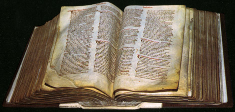
Domesday Book
(National Archives)
As most people tend to look at Domesday simply for their entry, they don’t tend to question the document as a whole: the truth is that it is filled with errors, omissions and inconsistencies so the whole thing can be somewhat bewildering at best. It would be churlish to suggest that I am rubbishing the document, of course I am not, but some general understanding of the book is needed to give context to an entry because what you see isn’t necessarily what you get. I have therefore decided to dust of my various texts on the book (see bibliography), re-read them and then write two articles covering some of the local places within the mighty tome. The first article will give my suggestions on the Wyrley entry and the second at a later date, if I ever get over the first 🙂 , will look at the absence of Walsall and the strange position of Bloxwich. Both articles will be preceded by the same general outline to the Book, so they make more sense if you only read one of them; but please remember scholars have built careers on this topic alone and I am just giving a superficial outline of how I understand it.
Background to the Staffordshire Domesday
The Domesday Book was compiled on the order of William I (known as the Conqueror or the Bastard). The Anglo-Saxon Chronicle places this order to Christmas 1085, when William held court at Gloucester. Because of the depth of the inquiry the book later became known as the ‘Domesday Book’, referring to a biblical doomsday or the day of judgement, but it wasn’t called this at the time. The project was known as the ‘great description of England’ (although parts were not covered) or the ‘Book of Winchester’ (where the royal treasury was situated). The book was primarily completed within a year, but left abandoned at the death of William in 1087. The rapidity with which the exercise was completed showed the sophistication of both central and local government at the time.
So what is it? The Chronicle’s entry smacks of Saxon oppression: ‘[William sent men] into every shire [to] find out how many hides there were… what land and cattle the king had himself… what dues he ought to have… how much land his archbishops had, his bishops and his abbots and his earls, and what or how much everyone who was in England had… so very narrowly did he have it investigated that there was no single hide nor yard of land, nor indeed … one ox or cow or pig which was left out… and these records were brought to him afterwards’. The book is more than a tax document and more than a list of landholders: with William facing problems in England, France and attacks from Scandinavia, it seems to me that it is an account of the resources of England available to a new regime. It must be remembered that the under the Norman system, all land was held from the king.

Part of that entry in the Chronicle
(Bodleian Library)
How was the survey carried out? Well it isn’t known for sure, but there must have been a huge collaboration between local and central government. Method and terminology seem to indicate shires were grouped into circuits, however there is disagreement as to the number of circuits and even to which circuit Staffordshire was included. On top of this there were differences in the reporting from shire to shire.
If the slightly later Ely survey is anything to go by then central government took the form of a team of esteemed commissioners, likely with no connection to the circuit and shires they were assessing; local government likely took the form of the shire and hundred courts, supported by lords, stewards and priests. The survival of the Exeter (Devon) and Little Domesday (East Anglia) suggest that the returns supplied to the commissioners were originally more detailed and then condensed down into an incomplete final version, which is the actual Domesday Book.
After the shire, the next level of arrangement was by major landholder or tenant-in-chief (bottom-left corner of the photo below) . Only 17 are listed in the index for Staffordshire, however the 17th entry is for ‘odd possessions’. In the index the king leads the way, followed by the clergy and then the lay tenants. Arrangement then continues with possessions listed by each hundred. A hundred was possibly an ancient boundary, encompassing 100 or 120 hides of land, which would support 100 families (and provide 100 men for military service). Staffordshire has 5 hundreds; in 1086 Great Wyrley, Rodbaston and Cannock were in the Cuttlestone hundred and Lichfield, Norton Canes, Little Wyrley, Walsall, Wednesbury and Bloxwich were in the Offlow hundred .

Staffordshire Domesday, opening folios.
(Open Domesday)
The final method of arrangement was not by the village or hamlet, but by the manor. A village could be split between more than one shire or more than one landlord: Willenhall is a good local example, being split between the king and the Canons of Wolverhampton. So what do we mean by a manor? This is difficult. A manor is the economic, legal and administrative centre of an estate, ran by a ‘lord’ or his steward, and assessed for tax. That estate can be a single hamlet or village and have its own entry in Domesday; equally it could also be the centre of a group of ‘manors’, which then become sub-manors or berewicks and appear under the Domesday entry for the chief- manor: Norton Canes and Wyrley appear under Lichfield for example and, bizarrely, Bloxwich appears under Wednesbury. Saying that, a sub-manor to one chief-manor could be massively greater in size than that of a chief-manor elsewhere. Confused? No, then I clearly didn’t explain well enough 🙂 .
The Ely survey, as well as the Domesday itself, gives an insight into the questions asked by the commissioners: the name of the manor, who held it at the time of King Edward the Confessor (Harold being seen as a usurper), who holds it now, how many hides there are (measurement of land for taxation purposes, but varied enormously between 40 and 120 acres), how many ploughs are held by the lord and how many belonging to the peasants (a plough-team would consist of 8 oxen), how many unfree peasants there were (villeins, cottars and bordars, depending on status), how many slaves, how many freemen and sokemen (free, but owed some dues to the lord), how much woodland, how much meadow, how much pasture, how many mills, how many fisheries, how much had been added to or taken away from the estate, what it used to be worth in the reign of Edward and what it is worth now. Finally, it was also to be noted whether more revenue could be extracted.
Staffordshire is shown up in Domesday book as an economically backward county with few landholders; indeed, Slade wrote of it as ‘primitive [and] poor’. Staffordshire is a big county yet covers only a few pages, which shows just how sparsely populated it was at this time; in fact there are only two other shires in England that have smaller sections within Domesday, those being Middlesex and, not surprisingly, Rutland.
By 1086 the 100 – 120 hides per hundred, mooted by early Domesday scholars, seems to have become corrupted. Further, various scholars have claimed that these hides were originally (very late Saxon period) arranged in 5-hide units (or multiples): Willenhall being a good local example where the king had 3 hides and the Canons of Wolverhampton had 2. Attempts were made to trace these units in 1919, with varying degrees of success in my opinion.
Domesday entry just for King William’s land within Willenhall.
(Open Domesday)
I mentioned errors, omissions and inconsistencies before, so really I need to give a few examples. Regarding omissions, nationally you wont find London, Winchester or Bristol in the Book, whereas locally there is no Tamworth (despite being the ancient capital of Mercia) and famously of course, Walsall. Slade says, ‘many villages of today are not in the survey’, so on a smaller scale, Darlaston is an example of such. Examples of inconsistency are legion. One question asks about the amount of pasture within a manor – yet there is not one acre listed in the whole of Staffordshire. If we look at local manors and their sub-manors, then sometimes the returns for the sub-manors are listed with the sub-manor, sometimes in the main manorial return and sometimes both.
Wyrley in Domesday
Other than the place-name evidence, Domesday Book appears to be the first evidence we have of the name and what actually constituted the settlement of Wyrley; however, the entry in my opinion is very misleading. The entry forms part of the Lichfield estate of the Bishop of Chester (that is the Bishop of Lichfield, the Bishopric having been moved) and this already creates problems. The Lichfield entry is actually broken in two and while this doesn’t make the returns inaccurate, it is surely an error.

First part of the Lichfield return
(Open Domesday)
The entry starts off with the return for the main manor of Lichfield, before listing several sub-manors of which one is Wyrley; these have a land allotment but no values. At the end of the Bishop’s manors is another entry for Lichfield. It states that Lichfield had ‘already been described’, but goes on to give the area of woodland missed in the first part of the return and then to list several other sub-manors, with land allotments and resources such as mills, population and meadow. The value, it stated, was included in the total in the first entry.
Turning to the Wyrley entry, it is in fact a combined one where it and Norton Canes together form one sub-manor (or berewick). The entry is one of several ‘members’ to belong to Lichfield: Packington (land for 4 ploughs), the two Hammerwiches (5 carucates of land), Stychbrook (land for 1 plough), Norton Canes and Wyrley (4 carucates of land) Rowley (1 carucate of land). All these are described as ‘waste’.

The Norton and Wyrley entry under Lichfield
(Open Domesday)
The fact that they are listed as ‘waste’ is interesting. Original thoughts saw ‘waste’ as being land that had been devastated by the Norman ‘harrying of the north’, as they sought to quell the land after Hastings. The fact the estate would have been on Watling Street (a route that must have been used in the Norman advance north) may seem to add credence to this, however, this is a little too simple in my opinion. The definition should be widened to one of land that is, or appears to be, unproductive to some degree. This could be for a number of reasons and may include land exempt from taxation because it is not tenanted, land deliberately left fallow or land that has been turned into ‘forest’ under William’s new forest laws. William I turned huge swathes of land over to forest for royal hunting. Ultimately, we have no idea.
The next issue is the land allotment and this made my alarm bells ring for a few reasons. The first of these because of the terminology used. Despite the assessment for Lichfield being in hides and some of the other sub-manors accompanying Norton and Wyrley being in plough-lands, our entry uses carucates. Generally the carucate is seen the Danelaw version of the hide, but back in 1919 Charles Bridgeman suggested it may mean a ‘conjectural’ assessment. It feels that the almost lazy use of ‘the two Hammerwiches’ and shunting Norton with Wyrley may support this – as if nobody actually assessed it – but other entries are combined and so the jury is out on this. I must admit that I struggle with the 4 carucate assessment. If it is correct then the size of the assessment of Norton and Wyrley is somewhat bigger than that of Wednesbury, its three dependants and Bloxwich combined. Indeed, Lichfield was assessed at around 25 hides and assuming Norton and Wyrley’s total is within the Lichfield total, it takes up around one sixth of Lichfield’s geld assessment.
Let us say these carucates are real and the full 120 acres. The first problem is that the ratio of the division of land between Norton and Wyrley is unclear: meaning that Norton may have had three carucates and Wyrley just one, for example. A carucate could also be sub-divided and dispersed over a wider area. This leads onto the question of just why the entry is combined, considering we are not talking about a small assessment. I can only imagine that either one of the two sites didn’t have a manorial building as such and was attached to the other, or the two manors had been pulled together before becoming a part of Lichfield.
Next we turn to the question of what constitutes Wyrley in this entry; does it include Little Wyrley, Great Wyrley, Cheslyn Hay and Landywood for example? The suspicion is that this entry is actually for Little Wyrley and not even all of Wyrley. This suspicion carries further weight when, even as late as the 14th century, tax lists have Great Wyrley listed separately from a combined ‘Norton and Wyrley’ entry. Of course, where the boundary between Little Wyrley and what would now be considered Great Wyrley is unclear.
There is other evidence that Great Wyrley is not represented by the Wyrley entry. In 1086, as we have seen, the Norton and Wyrley entry is for land in the Offlow Hundred and in the gift of the Bishop. An entry in the Plea Rolls for 1270 contains an appeal in which Richard de Loges claims that in 1066 his ancestor, Richard (the Forester), held Great Wyrley from Edward the Confessor by sergeanty – that is, in his capacity as the king’s chief forester. According to the Book of Fines of 1275 and Domesday Book itself, it was William I that actually bestowed the title on Richard. This is important, as it means in Domesday Great Wyrley was in the gift of the king and was actually in the Cuttlestone Hundred. In short, Great Wyrley and Little Wyrley were in different hundreds and had different land-owners.
EJ Homeshaw, in his Great Wyrley guide, claims that a tract of forest was indeed transferred between the two hundreds in the wake of the conquest and from the Bishop to the King. If this is true, then it can’t have included the Great Wyrley area if the plea of de Loges was correct, as his ancestor had been granted the land from by a Saxon king. If the Book of Fines is correct then it could be the area that incorporated Great Wyrley and possibly Cheslyn Hay, as it was William I who made the grant.
So, if Great Wyrley is not represented by the Norton and Wyrley entry in Domesday and it existed then, which it did according to the later Plea Roll, where is its entry? The first possibility is quite straight-forward: Great Wyrley, Landywood and Cheslyn Hay were simply too small and too unimportant to be listed separately. The next possibility is that they were missed-out for some reason – and this is not as silly as it sounds – after all, you will not find Walsall, Tamworth or the royal lands in Wolverhampton in the Book.
One possibility is that it is incorporated into another entry. Richard the Forester held several estates in Staffordshire according to the Domesday Book, the most valuable being at Rodbaston in the Cuttlestone Hundred. Whilst Great Wyrley is not listed separately, it is possible that its revenues were incorporated into this estate. The distance between the two is not an issue if you accept Shelfield is within the manor of Wednesbury. If a tract of land had been transferred from the Bishop, it may not have been mentioned by name, but it may have been reflected in the huge increase in value of this estate: it increased from 2s to 15s between 1066 and 1086.

Rodbaston, is this where Great Wyrley is described?
(Open Domesday)
Alternatively it may well be represented in the Cannock entry. Cannock is listed twice, as it had two land-holders, but the majority is under the lands owned by the king in the Cuttlestone Hundred. Cannock was held by Earl Algar prior to the conquest but ‘paid nothing’ in 1066. By 1086 it was valued at 20s and again, this could be due to an added tract of land. It is listed as having ‘dependencies’, but none are named individually. It is listed as having one hide (carucate) of land, but potentially far more (this is due Domesdayologists disputing the far from clear relationship between the hide, carucate, ploughland and plough). 8 villagers and 3 smallholders are listed. It has woodland, 4 leagues by 8 leagues (a league is around 1½ miles).

Cannock entry in Domesday – could Greta Wyrley and Cheslyn Hay be incorporated into it?
(Open Domesday)
I think there is little doubt that the entry in Domesday is for Little Wyrley, but as to whether Great Wyrley, Cheslyn Hay and Landywood are represented is anyone’s guess. What I hope I have shown is that the Domesday Book is often far from clear and that therefore the main value of the entry is that it indicates the status (a combined entry with Norton and being waste), a rough size (4 carucates) and the ownership of the land (the Bishop of Lichfield/Chester).
If you got to the end of this article, you deserve a gold star – like you got at infant school.

My thanks to
Professor John Palmer and George Slater and the Open Domesday Website – http://domesdaymap.co.uk/
National Archives
Bodlian Library
Domesday Book, Staffordshire: ed John Morris, Phillimore.
Staffordshire Domesday: CF Slade, Staffordshire County Council
Domesday Studies: Ed JC Holt, Boydell Press
The Domesday Book- A Guide: Weldon Finn, Phillimore
An Introduction to Domesday Book: Weldon Finn, Greenwood
Staffs Historical Collections, 1919: Staffordshire Hidation, Bridgeman & Mander, Wm Salt Arch Soc.
Staffs Historical Collections, 1919: Notes on 1916 vol, Bridgeman, Wm Salt Arch Soc.

We were never awarded stars at school! this is maybe my first ever 🙂 I always imagine the Doomsday surveyors sitting in local inns, making things up and generally having a laugh. An inn would have been a good place to gather the necessary information (that is if there were such a thing as inns in 1086)? I ask a public house expert! Seriously though, would people not be eager to hide much of their wealth from the king, “tax evasion” (the omittance of London seems suspicious). Anyway I have a headache now!
Space was left in the Book for London, but it was never written up. It seems that people were happy to be assessed and the commissioners were not from the shire in question. At the end of the day it was a brilliant achievement, but still rushed.
Bloody Normans, what ever did they do for us?